

Camp Stay
Tent 4 person sharing
Campfire
no
Distance
26KM
Pickup-Drop
Manali-to-Manali
Altitude
14,065ft
Duration
6Days/5Nights
Difficulty
Moderate
Environment
Green trail,Grassland,Alpine Meadows
Trek Fee: 14999/-
Inclusions and Exclusions
Overview
One of the Most Dramatic Crossover Treks in the Himalayas
Hampta Pass is a 14,000-foot-high connection between two starkly different landscapes. On one side, you have the lush greenery of Kullu Valley—thick forests, open meadows, and wildflowers lining the trail. On the other side of Hampta Pass, you step into the barren, rugged beauty of Lahaul. The terrain is stark, the mountains bare, and the skies endlessly blue.
Traditionally, it used to be a Summer Trek. But when we did the trek in monsoon, this sudden shift in landscapes felt almost magical. Standing on the top of the pass, what’s ahead and behind are two different worlds. Even more remarkable is how quickly these changes occur. Most pass-crossing treks are longer. They require much more time and effort. But at Hampta Pass, you witness this shift in just 25 km of moderate level trekking. This is where the Hampta Pass Trek stand out for us.
Hampta Pass Trek Itinerary
Day1:Manali To Chhika Via Jobra | Walk Through Forest Cover
- Altitude:
Manali - 2,100 m / 6,400 ft
Jobra - 2,800 m / 9,100 ft
Chhika 3,100 m / 10,100 ft. - Drive Distance (Manali to Jobra): 16km | 1hr.
- Trek Distance (Jobra to Chhika): 3km | 2hrs.
- Enough water through the trail.
- Easy to moderate trail.
- Stay in a tent
- Manali to Manali to Manali Transport.
- Reach Chhika campsite by 5 pm.
The trekking expedition starts at Manali where you will be driven to Jobra in a vehicle. Manali lies at an elevation of 6,300 ft. so it is a good place to acclimatize before you start the trek. The drive takes you along 40 hairpin bends before you arrive at Jobra, the drive time is around 2 hrs. You will get to see the beauty of the Kullu Valley all along the ride. Jobra is the base for your trek to Hampta Pass. It is situated at an altitude of 9,200 ft and the trek to Chhika will take you to an altitude of 10,100 ft.
Today is an easy trek along the banks of Rani Nallah through a mixed forest of pine, green maple, and birches. The trek initiates from Allain Guhugal Hydel Project junction and after you cross the main road, you follow the small path leading into a forest of Pine trees and other conifers like Maple, Oak, Deodar, and Toss. The slope that you will climb is not steep and is quite easy to climb. The surroundings are very beautiful, take a moment to appreciate the beauty of the environs before heading into a lush meadow strewn with small rocks all around. Twenty minutes into the trek and you will arrive at the bend that overlooks the meadow.
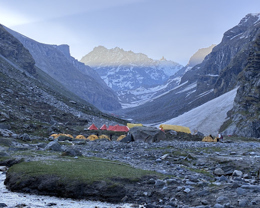
A little into the meadow the Rani Nallah comes into view, it flows through the middle of the meadow making it look like a picture right out of a fairytale. Walk through the meadow or climb up the hill on the left-hand side, either way, you will reach Chhika at the end of the vast meadow. Climbing the hill and descending to Chhika is the easier route and the campsite lies in a huge patch of a green clearing. Rani River flows through the middle, which makes the perfect setting to pitch up a tent. You may also spot horses grazing in the meadows that make a perfect setting for some Instagram-worthy photographs.
Day:2 Chhika To Balu Ka Ghera | Stay At A Beautiful Campsite
- Altitude: 3,600 m/ 11,800 ft.
- Trek Distance: 6-7km | 5-6 hrs.
- Altitude Gain: 700 m/ 2300 ft.
- Moderate trail, gradual ascent.
- A packed lunch will be provided.
- Enough water on the way.
- River crossing, boulder walk, and colorful tiny flowers on the way.
The next destination is Balu Ka Ghera. While the area is not visible from the Chhika campsie, from the direction of the trail you can guess that it falls on the right-hand side. The trail will lead through boulders and rough terrain and the grade of the trek today is also an easy one and can be completed without any difficulty.
The entire stretch of the river's right bank is lined up with amazing dwarf Rhododendron trees. These trees will cover the lower and the central region and a cluster of silver birch trees cover up the upper region. Once you have reached the end of the silver birch trees, wait a moment and look back to marvel at the entire range of Dhauladhar snow-clad peaks in front of you. The view is very picturesque. You will reach a clear stream waterfall to the left at a distance. This is the best place to fill your bottles.
Day:3 Balu Ka Ghera To Shea Goru | Panoramic Mountain Views
- Altitude: Hampta Pass - 4,300 m / 14,100 ft | Shea Goru- 3,900 m/ 12,900 ft
- Trek Distance: 7 km | Duration: 10 hr
- Altitude Gain: 520 m/ 1,700 ft.
- No water point on the way (depends on the condition of snow)
- First 1 hr gradual ascent then steep ascent till the pass
- Packed lunch at the pass, enjoy the view of Indrasen Peak
- Around 2 hrs of steep descent and 1 hr of flat walk from the pass to the campsite
- The coldest part of the trek
- Stay in a tent.
You can split the journey into two halves, a steady ascent on a moderately steep slope to Hampta Pass, hence a sharp descent to Shea Goru. The highest altitude will be achieved on this day at Hampta Pass (14,100 ft). The day starts by heading towards the mountains you spotted the previous day near Balu Ka Ghera. The trail is along the riverside. The view is amazing, tiny yellow and orange flowers along the river banks enhance its beauty.
Day:4 Shea Goru To Chatru And Drive To Chandratal | Bask In the Serenity Of The Lake
- Altitude: Chatru- 3,350 m/ 11,000 ft.
- Trek Distance: 7 km | 5 hr.
- Drive Distance: 50 km, 3-4 hr to Chandratal and back to the campsite, either on day 4 or day 5 (depending on road and weather conditions).
- Altitude Loss: 550 m/ 1,900 ft.
- Gradual descent on the moraine.
- Start early in the morning.
- 2 to 3 water sources on the way.
- Hot lunch at campsite.
You will cover Shea Goru to Chatru by foot and it will take approx 5 hours of easy downhill trek. Shea Goru is placed at an altitude of 12,900ft and Chatru at 11, 000ft. It is a gentle trek downhill from Shea Goru. The trail here again is by the side of the river valley between mountain ranges. Some places can be a little slippery so be careful.
Chatru can be located at a distance. No vegetation can be seen in the barren mountains. The tricky part comes next. You will have to be careful as the trail might sometimes lead you to the edges of mountains and ridges. The route has slippery parts too. So, sure-footed and careful navigation is required to go further. Nevertheless, the trek is not as difficult as it sounds. You will for sure enjoy the sliding. Getting down the mountains will consume another two hours of your time. You will notice the Chandra River flowing below and a road that goes by its side. More than two Glaciers come next which are to be crossed. The other side of the Glacier is Chatru, the next camping zone. Choose a location that has the river running around.
Chatru is a magnificent camping site; it is a consensus of the three passes, Hampta, Rohtang, and Spiti. The location is just about another two hours away.
Day:5 Chatru To Manali | Bid Adieu To The Mountains
- Drive Distance: 65 km | Duration: 5-6 hr.
- Breakfast at the campsite.
- Lunch on the way (not included in cost).
- Make your further travel plans from Manali.
It is time to say goodbye to the Spiti Valley and head back to Manali. A ride back from the Chatru campsite to Manali is scheduled for day 5. After this 5 hour journey full of mellow reminisces of the hills, you will be reaching Manali in the afternoon. An overnight journey after 08:00 pm to Delhi will hopefully work out best.
Chandratal Lake
A visit to Chandratal will be either on Day 4 or Day 5. You can hike up to the marvelous Chandratal Lake (known as the moon lake). Chandratal Lake is 50 km from Chatru campsite. The sheer blue color of the lake has an amazing effect on the surroundings. You can visit Chandratal only in the summer months if road and weather condition permits us. If not, you will have to drive directly from Chatru to Manali and skip Chandratal altogether.
 Inclusions — What’s Included in Your Trek Package
At The Peak Freaks, we aim to provide a seamless, safe, and immersive trekking experience. Your trek fee includes:
 Accommodation:
- Stay in high-quality Glamping tents on Four persons sharing basis during the trek.
- Sleeping bags, Air mattresses, and pillows provided at each campsite.
- Separate kitchen and dining tents at campsites.
 Meals:
- All meals during the trek – nutritious, freshly prepared vegetarian food (breakfast, lunch, evening tea/snacks, and dinner).
- Clean drinking water (boiled or filtered) available at all camps.
- Meals start with lunch on Day 1 and end with breakfast on Day 5.
 Trek Team & Safety:
- Experienced and certified trek leaders and local guides for the entire route.
- Support staff including cook, helpers, and porters for logistics and camp setup.
- First Aid medical kit, oxygen cylinder, and pulse oximeter for altitude monitoring.
- Radio/walkie-talkie for communication where needed.
 Logistics:
- Transportation from Manali to Manali in shared vehicles.
- All trekking permits and forest entry fees.
- Mule/porter support for carrying common equipment (tents, kitchen gear, etc.).
 Other Perks:
- Pre-trek briefing and orientation in Manali.
- Basic hygiene kit at camps (toilet tents, wash basins, etc.).
- Access to emergency backup vehicle at Chatru (subject to availability).
- Certificate of completion at the end of the trek.
 Exclusions — What’s Not Included
While we cover most essentials, a few things are not included and need to be arranged by you:
 Transport:
- Travel to and from Manali from your city/home (bus/train/flights).
- Any personal cab or private vehicle bookings for early return or side visits.
 Personal Equipment:
- Trekking gear like shoes, jackets, poles, gloves, and backpack (can be rented).
- Personal medicines, sunscreen, lip balm, and toiletries.
- Power bank, headlamp/torch with extra batteries.
 Other Costs:
Tips/gratuity for guides, cooks, or staff (optional, but appreciated).
Any costs arising due to delays, natural calamities, roadblocks, or medical emergencies
Camp stay in Manali before or after the trek.
Snacks, bottled water, or beverages not included in group meals.
Charges for visiting Chandratal Lake (if roads are closed or need private vehicle).
Things to Carry for Hampta Pass Trek
Packing smart is key for a safe and comfortable Himalayan experience. Here’s your complete checklist:
 Clothing (Layering is essential)
- 2 full-sleeve quick-dry t-shirts (one for trek, one spare)
- 1 light fleece jacket or pullover
- 1 heavy down or padded jacket (for high-altitude cold)
- 2 pairs of trekking pants (preferably quick-dry; avoid jeans)
- Thermal innerwear (top & bottom) – 1 pair
- 3 pairs of woolen/trekking socks + 2 regular socks
- 1 woolen cap + 1 sun cap or hat
- 1 pair of gloves (1 woolen, 1 waterproof if possible)
- Raincoat/poncho (a must for sudden showers)
- Buff or scarf (for neck/head protection)
Footwear
- Sturdy trekking shoes with good grip and ankle support (already broken-in)
- 1 pair of slippers/sandals for campsites
 Bags
Bags
- 1 backpack (50–60L) with rain cover
- 1 daypack (10–15L) for water, camera, and essentials (if you’re offloading main bag)
 Toiletries & Hygiene
- Toothbrush, toothpaste, face wash
- Biodegradable soap or wipes
- Quick-dry towel
- Toilet paper & tissues
- Hand sanitizer, lip balm, moisturizer, and sunscreen (SPF 50+)
- Menstrual hygiene products (if applicable)
 Personal Medications & First Aid
- Personal medication (if any)
- Basic medicines: Crocin, Combiflam, Avomine (motion sickness), Digene, ORS, antiseptic cream
- Band-aids, crepe bandage, cotton, Dettol
- Diamox (only after consulting your doctor) for altitude sickness
 Accessories
- Headlamp/torch with extra batteries
- Sunglasses (UV-protected, wraparound preferred)
- Water bottle (1L) or hydration pack
- Energy bars, dry fruits, ORS packets, glucose
- Trekking pole (optional but helpful for beginners)
 Miscellaneous
- Power bank (mobile charging is not available on trail)
- Camera/GoPro (optional)
- Small notebook & pen (for journaling)
- Identity proof (Aadhaar card or passport photocopy)
 Important Trekking Tips
Make the most of your Himalayan adventure with these helpful tips from The Peak Freaksteam:
 Before the Trek
- Prepare physically: Cardio, squats, and leg strengthening exercises 3–4 weeks before the trek.
- Avoid alcohol and smoking at least 1 week before — they affect your oxygen levels.
- Get a medical check-up if you have existing health conditions or are above 45.
 During the Trek
- Hydrate constantly — drink at least 3–4 liters of water daily.
- Pace yourself — slow and steady wins the mountain! Avoid racing ahead.
- Don’t skip meals — your body needs fuel for high-altitude hiking.
- Inform your trek leader immediately if you feel dizzy, breathless, or nauseous.
 Safety & Environment
• No littering — keep the Himalayas clean. Use waste bags for wrappers or plastic.
• Stay with the group — straying from the trail can be risky.
• Respect the local culture and wildlife — be a responsible trekker.
• Always keep head and ears covered in high winds or cold conditions.
Frequently asked questions
Hampta pass trek difficulty level range from easy to moderate level. If you’re healthy and fit both physically and mentally, then you’re fit to attempt this trek. Hampta Pass trek comprises different terrains and is considered difficult as it has a considerable amount of ascent and descent. Hampta Pass trek, however, is a bit steep but doable.
Hampta Pass trek is a popular high altitude trek in the Pir Panjal mountain range of the Himalayas in Himachal Pradesh, India. It crosses the Hampta Pass at an altitude of about 14,000 feet above sea level and connects the Lahore Valley with the Kullu Valley. Where is Hampta Pass Trek?It starts from Manali in Kullu district and ends in Lahaul valley near Chaturgram. The journey passes through beautiful valleys, glaciers, high deserts and meadows.
You consider the Hampta Pass trek moderate to strenuous hike due to the high altitudes, snow patches, and some steep climbs to the top of the lake and physically demanding great ground strength and first-hand knowledge of hiking.
A typical Hampta Pass trek takes 4-5 days, with a total distance of about 35-40 km in one direction. The long trek through Sia Gol takes 6-7 days.
The highest point reached on the Hampta Pass trek is Hampta Pass itself, which is about 14,035 feet above sea level Are there any famous campsites along the way? Yes, the famous camping spots include Jwala, Bar Ka Gera, Siya Gol and Chatur, where trekkers often stop.
Himtrek does provide easy accessibility to almost all types of equipment required for the trek on a rental basis with reasonable prices and extremely good quality. The equipment can be arranged on prior notice.
The highest altitude of Hampta Pass Trek with Chandratal is 14,107 ft. The Hampta Pass Trek is a popular trekking route in the Pir Panjal Range of the Himalayas, located in the Indian state of Himachal Pradesh. The highest point of the trek is the Hampta Pass itself, which stands at an elevation of approximately 4,270 meters (14,009 feet) above sea level.
The Hampta Pass Trek is a moderate to challenging trek in the Himalayan region of Himachal Pradesh, India. The total distance covered during the trek varies slightly depending on the specific route taken, but typically ranges from approximately 24 to 28 kilometers (15 to 17 miles) one way.