


Camp Stay
Tent 4 person sharing
Campfire
no
Distance
33 KM
Pickup-Drop
Manali to manali
Altitude
13600ft
Duration
5Days/4Nights
Difficulty
Moderate
Environment
Green valley Grass land
Trek Fee: 13999/-
Inclusions and Exclusions
Overview
The Sar Pass Trek is a highly popular trekking route in the Parvati Valley of Himachal Pradesh, India, attracting adventure enthusiasts and nature lovers from all over the world. The trek is moderately difficult, making it accessible to those with a reasonable level of fitness and experience. The trek takes you through dense forests of pine, oak, and deodar trees, pristine meadows dotted with colorful wildflowers, and charming villages where you can interact with the locals and learn about their way of life.
Sar Pass Trek Itinerary
Day:1 Kasol To Grahan Village
- Altitude:
- Kasol: 1,700 m / 5,600 ft
- Grahan Stop: 2000 m / 6,500 ft
- Grahan Village: 2,350 m / 7,700 ft
- Drive Distance: 8 Km | 45 minutes
- Trek Distance: 2 Km | 1 hr
The Sar Pass Trek journey begins with an 8 km drive from the beautiful mountain village of Kasol to Grahan Stop, followed by a 2 km steep ascent to Grahan Village in Himachal Pradesh. Grahan Village is renowned for its enchanting evergreen forests and creeks, nestled beside the gushing Parvati River. The journey commences with an 8 km drive to Grahan Stop. Upon reaching the last road point at Grahan Stop, we'll commence the 2 km steep ascent to Grahan Village, our first-day campsite. The initial part of the trail passes through dense coniferous forests and the aroma of the pine trees will invade your senses as you walk through the forest.
After walking through the forested patch for some time, the forests will eventually give way to grasslands and you can see some local vendors with their tea stalls. These stalls also sell Rhododendron syrup, which is mixed with water to make a very refreshing drink. Grahan village is not very far. From here, it is about a steep climb of one hour before you enter the picturesque village setting.
Grahan is situated at the top of a hill and we will camp here for the night. Mobile coverage is sometimes available in Grahan but it is very erratic. The campsite is surrounded by Rhododendron trees making it look even more beautiful. After having a delicious lunch at the campsite, you can go about exploring the quaint village and its surroundings. The pleasantness of the scenery with the beautiful mountain views will captivate you. After a delectable dinner, you will retire to your tents ending the first day of trekking.
Day:2 Grahan Village To Min Thach
- Altitude:
- Grahan Village: 2,350 m / 7,700 ft
- Min Thatch: 3,400 m / 11,150 ft
- Trek Distance: 8 km | 5-6 hrs.
Today we will trek to Min Thach, a beautiful meadow that falls en route to your trek. To reach Min Thach, we will follow the trail that goes north from our campsite at Grahan, this path will lead you to Min Thach. We will start our trek post a hearty breakfast at the Grahan campsite.
After walking for some time, wonderful mountain views begin to open up and the trail to Min Thach will be on your right. The climb to the meadow is a little steep and sometimes the trail becomes a little confusing, follow your trek leader’s instructions during these confusing patches. After walking for a few hours through the dense forests, it will open into a grassy ridge, this is Min Thach clearing and we will find a proper location here and pitch our tents for an overnight stay. Min Thach is usually used by locals to graze their cattle.
On the northwest side, you will get views of Chanderkhani and its adjoining mountain ranges stretching across the horizon. In the southeast, it is lined with dense evergreen forests. Sometimes there are also seasonal vendor stalls that sell tea, coffee, and the like. There’s also a water source in the form of a tap, and you will get potable water here. This is a good place to camp as the ridge protects the tents against strong winds. Also, having a day between Grahan and Nagaru campsite allows for the body to acclimatize well to the weather and the altitude. Sunset and sunrise views are especially beautiful here. Once you reach the campsite, relax and enjoy a beautiful sunset over the snow-clad mountains. After a hot dinner at the campsite, you will end the day and retire in your tents.
Day:3 Min Thach To Nagaru
- Altitude:
- Min Thatch: 3,400 m / 11,150 ft
- Nagaru: 3,800 m / 12,400 ft
- Trek Distance: 5 km | 4-5 hrs
From Min Thach, you get glimpses of Nagaru and it doesn’t seem all that far but we are not going to take the straight ridge path to Nagaru, rather the trail entwines up towards the south and follows into the woods. Depending on the time you are visiting the trek, you may find patches of snow on the trail. It’s a good idea to start early as most of the time the weather remains favorable up until noon, post which it can be unpredictable. So, we will start out early today.
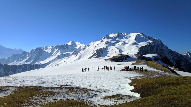
Day:4 Nagaru To Biskeri Thach Via Sar Pass
- Altitude:
- Nagaru: 3,800 m / 12,400 ft
- Sar Pass: 4,200 m / 13,600 ft
- Biskeri Thach: 3,350 m / 11,000 ft
- Trek Distance: 12 km | 7-8 hrs
Today is an exciting day of trekking and also the longest trekking day. Today will head to Sar Pass! We will start the day early and wake up before dawn as we have a distance of 12 km to cover. The climb to the Pass is much like yesterday and you will use the same techniques. We will climb along the ridge line in a southward direction, there will be a couple of steep stretches that would test your physical and mental endurance. Keep a steady pace as you climb these stretches and cross the snow patches.
Day:5 Biskeri Thach To Pulga And Drive Back To Kasol
- Altitude:
- Biskeri Thach: 3,350 m / 11,000 ft
- Pulga: 2,400 m / 7,800 ft
- Trek Distance: 6 km | 4-5 hrs
- Drive Distance: 18 km | 1 hr
Today is the last day of trekking in the mountains and also the last day of your wonderful journey to Sar Pass. Today is also a long walk and we have to cover a distance of 6 km downhill. From Biskeri Thach a steep path goes down below by the side of a stream. The trail ends at a fenced plot of land so you have to go through the land before you hop on the trail again.
 Things to Carry for Sar Pass Trek
Packing smart is key for a safe and comfortable Himalayan experience. Here’s your complete checklist:
 Clothing (Layering is essential)
- 2 full-sleeve quick-dry t-shirts (one for trek, one spare)
- 1 light fleece jacket or pullover
- 1 heavy down or padded jacket (for high-altitude cold)
- 2 pairs of trekking pants (preferably quick-dry; avoid jeans)
- Thermal innerwear (top & bottom) – 1 pair
- 3 pairs of woolen/trekking socks + 2 regular socks
- 1 woolen cap + 1 sun cap or hat
- 1 pair of gloves (1 woolen, 1 waterproof if possible)
- Raincoat/poncho (a must for sudden showers)
- Buff or scarf (for neck/head protection)
 Footwear
- Sturdy trekking shoes with good grip and ankle support (already broken-in)
- 1 pair of slippers/sandals for campsites
 Bags
Bags
- 1 backpack (50–60L) with rain cover
- 1 daypack (10–15L) for water, camera, and essentials (if you’re offloading main bag)
 Toiletries & Hygiene
- Toothbrush, toothpaste, face wash
- Biodegradable soap or wipes
- Quick-dry towel
- Toilet paper & tissues
- Hand sanitizer, lip balm, moisturizer, and sunscreen (SPF 50+)
- Menstrual hygiene products (if applicable)
 Personal Medications & First Aid
- Personal medication (if any)
- Basic medicines: Crocin, Combiflam, Avomine (motion sickness), Digene, ORS, antiseptic cream
- Band-aids, crepe bandage, cotton, Dettol
- Diamox (only after consulting your doctor) for altitude sickness
 Accessories
- Headlamp/torch with extra batteries
- Sunglasses (UV-protected, wraparound preferred)
- Water bottle (1L) or hydration pack
- Energy bars, dry fruits, ORS packets, glucose
- Trekking pole (optional but helpful for beginners)
 Miscellaneous
- Power bank (mobile charging is not available on trail)
- Camera/GoPro (optional)
- Small notebook & pen (for journaling)
- Identity proof (Aadhaar card or passport photocopy)
 Important Trekking Tips
Make the most of your Himalayan adventure with these helpful tips from The Peak Freaksteam:
 Before the Trek
- Prepare physically: Cardio, squats, and leg strengthening exercises 3–4 weeks before the trek.
- Avoid alcohol and smoking at least 1 week before — they affect your oxygen levels.
- Get a medical check-up if you have existing health conditions or are above 45.
 During the Trek
- Hydrate constantly — drink at least 3–4 liters of water daily.
- Pace yourself — slow and steady wins the mountain! Avoid racing ahead.
- Don’t skip meals — your body needs fuel for high-altitude hiking.
- Inform your trek leader immediately if you feel dizzy, breathless, or nauseous.
 Safety & Environment
• No littering — keep the Himalayas clean. Use waste bags for wrappers or plastic.
• Stay with the group — straying from the trail can be risky.
• Respect the local culture and wildlife — be a responsible trekker.
• Always keep head and ears covered in high winds or cold conditions.
 Inclusions — What’s Included in Your Trek Package
- Transportation from Barsheni to Kasol.
- Shared accommodation throughout the trek.(Camping)
- All vegetarian meals, including a packed lunch on Day 1 and breakfast on Day 5.
- Services of a qualified and experienced trek leader.
- Supporting staff like a cook.
- Forest area entry permits.
- Basic medical aid kit.
- Camping and trekking equipment (tent, sleeping bags, gaiters, etc.) rental on an optional basis.
 Exclusions — What’s Not Included
- Expenses that are not mentioned in the inclusions.
- Porters/mules for luggage carrying.
- Personal expenses during the trek.
- Personal medications.
Frequently asked questions
The Sar Pass Trek is a popular trekking route in the Parvati Valley of Himachal Pradesh, India. The SarPass Trek offers breathtaking views of the snow-capped Himalayan range, leaving you spellbound as you trek through some of the most beautiful landscapes in the region, with majestic peaks rising all around you.
Sar Pass is located in the Parvati Valley of the Kullu district in Himachal Pradesh, India.
The Sar Pass Trek typically covers around 48 Kilometres and takes about 5 D/4N to complete.
The highest point of the SarPass is at an altitude of approximately 13,800 feet (4,200 meters) above sea level.
Sar pass trek best time is April to June (Sar Pass Trek in Summer) and September to November (Winter Circuit). Spring (April-June): Spring paints the panorama colourful with wildflowers. The climate is excellent, with mild temperatures, making it best for trekking. However, there can be occasional snowstorms at higher altitudes, so bring proper tools. Autumn (September-November) Witness a captivating display of converting foliage colorations. Cooler than spring, the autumn months provide comfortable trekking situations.
Avoid the monsoon rains (July-August) due to the risk of landslides.
Moderate physical fitness is required as the trek involves long walks, steep ascents, and descents. Regular cardiovascular exercise and stamina-building activities are recommended.
Essential gear includes sturdy trekking shoes, warm clothing, a good quality backpack, sleeping bag, trekking poles, a rain jacket, and basic medical supplies.
Sar Pass is rated as reasonably hard. Covering 48 km over 5 days, the trail gives a whole lot of landscapes to overcome. Prepare for steep ascents, descents that will test your patience, serene forest walks, and ability to handle glacier crossings. The maximum factor is Sar Pass at 13,800 ft. Proper guidance is fundamental for a successful and enjoyable Sar Pass Trek.
Acclimatization is essential for adjusting to better altitudes. Spend a few days in Kasol before hiking. Additionally, proper equipment like strong trekking shoes, layers, and a high-quality napping bag is vital. Experienced courses enhance the Sar Pass Trek revel in. Their know-how, navigation skills, and emergency handling provide peace of thoughts. Furthermore, porters are available to hold bags, allowing you to completely immerse yourself in the trekking enjoyment.